Category Archives: Politics

GA GOP Senate and House Maps Released, with Democratic Responses

Over the course of November 26-30, the GOP and Democratic caucuses in the Georgia Legislature have released their legislative map proposals.

Senate

  • Senate has 56 total seats, majority is 29.
  • The GOP’s proposed Senate map keeps the party composition at 33R-23D by packing two majority-black districts and eliminating two majority-white Democratic districts.
  • The Democratic response would shift the party composition to 31R-25D by adding two majority-Black districts in the southern Atlanta suburbs.
  • The Democrats are challenging the GOP Senate map as not fulfilling the court order. Won’t be surprised if it goes back to court.
  • Looking at the glass half-full, the current Senate party composition is the closest its ever been since Republicans gained the Senate majority in 2003-2004 for the first time since Reconstruction. They held it at 30R-26D, then increased it to a historic 39R-17D by 2016 before Democrats began bouncing back from 2017 onward.
  • More analysis by Niles Francis.

House

  • House has 180 total seats, majority is 91.
  • The GOP’s proposed House map brings the party composition of the House in 2025 to 99R-81D, down from the current composition of 102R-78D.
  • The Democratic response would modestly bring the party composition to 96R-84D by creating four majority-Black and one plurality-Black districts while double-bunking or flipping some Republican seats in the process.
  • Not as much Democratic outcry about the GOP House map as there is against their Senate map. However, there is disagreement from expert testimony on whether the House map passes the VRA smell test.
  • The last time the GOP was under 100 members in the House was the 148th General Assembly in 2005-2006, when the GOP held the House for the first time since Reconstruction. It was 99R-80D-1 independent. From there, Republicans ascended to a high of 119R-60D-1 independent 2013-2016 before Democrats bounced back from 2017 onward.
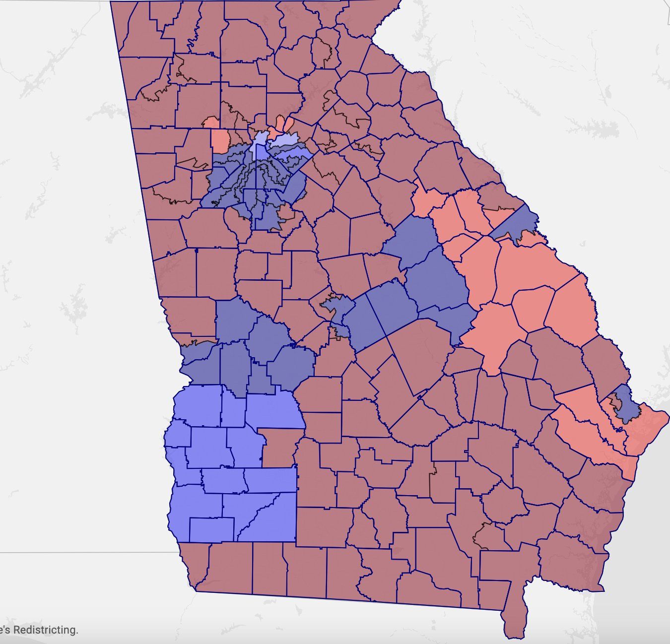
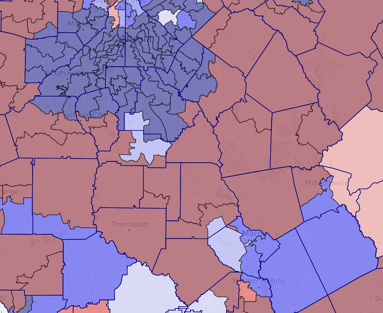
  • Under both House maps, Houston County finally gets Democratic House representation, with the map stretching HD143 (currently held by House leader James Beverly) to represent Warner Robins and northern Houston County while splitting central Macon into three blue districts stretching into surrounding counties.
    • Larry Walker was the last Democrat to represent a portion of Houston County in the House, way back in the 147th General Assembly (2003-2004).
  • Nothing in Greater Columbus was touched (obviously).
  • The map definitely strengthens the Black Belt’s African American representation a bit.
  • This map, and the Democratic response, reflects how the state’s popular vote has shifted to the left in the last several elections.
  • More analysis by Niles Francis.

Notes

  • Even on gerrymandering grounds, I wonder why the GOP wants to keep the current margins for Senate while conceding 3 seats in the House. I’d have expected at least one concession in the Senate for a 32R-24D map.
  • I wouldn’t be surprised if, in the congressional map phase, the GOP goes the route of packing more Black voters into Lucy McBath’s GA07 rather than redraw the west Atlanta suburbs between the 3rd, 6th, 11th, 13th and 14th districts. The Dems are hoping to keep the 7th intact.

Democrats are hoping for something like this (courtesy Stephen Wolf @PoliticsWolf):

8th Circuit Decides to Gut Section 2 of the Voting Rights Act

The 8th Circuit just ruled that there is no private right of action under Section 2 of the Voting Rights Act. 2-1, Bush and Trump appointees in the majority, Bush appointee dissenting. Affects litigation in the following states: Arkansas, Iowa, Minnesota, Missouri, Nebraska, North Dakota and South Dakota. Almost the entire 8th Circuit is Republican appointed. Expect SCOTUS action.

This was in response to the Arkansas NAACP suing the state over racially-biased legislative maps. Between this and both Georgia and Louisiana outright claiming on appeal that Section 2 is unconstitutional, the VRA is under direct Southern-Appalachian right-wing assault.

These full-frontal attacks on the Voting Rights Act, in the majority, come from white Southern Republican state legislatures and federal judges. The VRA did the bare minimum of forcing an imperfect compromise between white Southern rural voters and their Black neighbors, and we’re now paying for its loopholes which are now being exploited.

Pics related.

Estimated White Vote in the 2020 Presidential Election by County. Source: SplitTicket
Party swing in the 2004-2008 presidential elections by county, with the most Republican counties being singled out. Source: @vanillaopinions/Twitter
American Nations, as defined by Colin Woodard.

Tourism and the future Ocmulgee National Park and Preserve

Georgia currently has the following federally-protected areas:

  • 1 National Forest (Chattahoochee-Oconee)
  • 6 national historic parks, historic sites and/or military parks (Andersonville, Jimmy Carter, MLK, Kennesaw Mountain, Chickamauga-Chattanooga, and Ocmulgee Mounds)
  • 2 national monuments (Fort Frederica and Fort Pulaski)
  • 10 national wildlife refuges
  • 5 national natural landmarks
  • 12 federal wilderness areas
  • 1 wild and scenic river
  • 2 national trails
  • 1 national recreation area
  • 1 national seashore
  • 1 national marine sanctuary
  • 1 national estuarine research reserve

But apparently Georgia does not have any “national parks”. Also, most of the national forests are located north of Macon and the Black Belt.

Last year, the National Park Service commenced a study to estimate the feasibility of expanding the Ocmulgee Mounds National Historical Park as a full-on national park and preserve. This study also estimated the feasibility of expanding the protected area down the Ocmulgee River to south of Robins AFB. The study, which was completed and sent to Congress this week, ultimately estimated that both would be unfeasible due to cost and landowner opposition, but, in the interest of providing some form of protection for the river, recommended designating a smaller area as a National Heritage Area, a form of public-private partnership in which the NPS plays an advisory role while most of the work is carried out by a government or non-profit organization.

The group which advocates for this expansion has a website. And the congressional cohort which supports this initiative – Sens. Ossoff (D) and Warnock (D), Reps. Bishop (D) and Scott (R) – are not accepting the NPS study and are seeking for approval of the park in Congress. And if that doesn’t work, there’s always presidential designation as a national monument via the Antiquities Act, which could overrule opposition from local landowners and the Georgia Department of Natural Resources.

Political implications of national parks

Ever since first coming across research regarding how Democratic candidates for president (with the exception of Hillary Clinton in 2016) have done very well in rural counties whose economies depended on ecotourism, I have become deeply interested in how “new rural economies” which draw population have different economic outcomes and political interests than counties in “old rural economies” which depend on agriculture, livestock and/or mining. This held true for Joe Biden in 2020 as well, going so far as winning Teton County, Wyoming, the location of Grand Teton National Park and the most Democratic county in the deep-red state.

Granted, this doesn’t exactly seem to apply to ex-Confederate states, with several national parks and national forests in the Appalachians (i.e., Tennessee, North Carolina) not translating to rural gains for Democrats in presidential elections, or at least not drawing many transplants residents from outside of the region. But it somehow seems to work elsewhere in the United States.

National Heritage Area?

As stated, a National Heritage Area (NHA) affords fewer protections and restrictions on development, but can cover larger areas. An example is the new Alabama Black Belt National Heritage Area, which spans 19 counties and their cities in Alabama’s Black Belt region, is one of two NHAs in Alabama and is administered by the University of West Alabama (based in Livingston).

The NHA system, compared to the national park system, is very new, with NHAs first being designated in the 80s under Reagan and the NHA system only being established in January this year through the National Heritage Area Act (which also established the Alabama Black Belt NHA).

  • What tourism can NHAs draw compared to national parks?
  • Why are there so many more NHAs located east of the Mississippi than west?
  • Conversely, why are these so few national parks east of the Mississippi compared to west?

At the very least, NHAs seem to be easier to establish in the eastern U.S. because they don’t seem to require strict preservation of historic or natural properties, which works just fine for a much more densely populated and farmed region like the eastern U.S. Apparently, NHAs can even overlap each other (odd).

We need a park and preserve

IMO, Georgia needs a park and preserve which extends south of Macon:

  • the Southern half of the state is absent of any national parks, national preserves or national forests;
  • Dependence on mass agriculture is a population loser;
  • Federal protection of land would be a massive method of economic diversification
  • the Black Belt, which also forms a concentration of African-American majority counties stretching from Louisiana to South Carolina, does not have enough natural preservation and ecotourism going on;
  • The colleges and universities in the Macon-Warner Robins area (Middle Georgia State, Mercer, Wesleyan, Fort Valley State) would benefit from this as well.

If an Ocmulgee National Park and Preserve extending to south of Warner Robins is the way to make this diversification happen, then so be it. A National Heritage Area can be secondarily added to the surrounding area, but the park and preserve should also become a reality.

Are Alabama’s Democrats Ready? Are the South’s Democrats Ready?

I think about the following:

  • Out of the former Confederate states in the period between 1870 and 1901, only South Carolina sent at least two or more members to the U.S. House.
  • Georgia, Alabama, Louisiana, Mississippi, Florida, North Carolina and Virginia all sent one member at a time.
  • Texas and Tennessee never sent any members in the (post-)Reconstruction era
  • and Arkansas has never sent any African Americans to Congress to the present day

Now, Alabama will likely send two Black members to the U.S. House for the first time. And Louisiana is within spitting distance of doing the same for the second time in their history; the first time such a thing happened was in 1993, when William Jefferson (D-LA02 and Cleo Fields (D-LA04) went to the 103rd Congress.

The big question which sticks out for me is whether the Alabama Democratic Party will be prepared for this moment.

They certainly weren’t when Doug Jones won the once-in-a-blue-moon Senate special election in December 2017. In fact, the Alabama Democratic Party, the statewide Black Democratic club ran by Joe Reed, actively fought Jones for influence over the party’s bylaws and structure. The fight continues to this day, years after Jones lost his Senate seat to some bigoted football coach. And it seems like the DNC will have to pry some control of the ADP from the Conference. The Conference also tried to intervene twice in the Allen v. Milligan case to advocate for a more Black-majority 2nd and 7th district (to no avail), which went against the strategy of the plaintiffs as well as Rep. Terri Sewell in favor of two opportunity districts.

Now, however, with Sewell likely to win again in the 7th, the question remains as to the impact of whoever wins the 2nd congressional district. It’s most likely that the winner may be Black, or that whoever wins will have the support of the Black voting-age population in the 2nd district. But will the winner have more of a role in the Alabama Democratic Party? Will the campaign to defend both the 7th and the new 2nd district arouse the party out its current shape?

The same can be asked about Louisiana’s Democratic Party. It is heading to another era in the statewide wilderness with the terming-out of Governor John Bel Edwards and the likely election of a Republican governor. The party has been beaten down badly in other political aspects due to a massive decline in white rural support. Besides retaining Foster Campbell on the PSC in 2026 (he had his closest election in 2020), the other favorable political aspects above the state legislature have been:

  • the election of Davante Lewis to the PSC in 2022
  • the possible creation of a second opportunity congressional district around Baton Rouge for 2024

This is why I look forward to the impact of Allen v. Milligan on Southern elections. All of these issues can be challenged in federal court:

  • the potential second opportunity district in Louisiana
  • the reform of Mississippi’s State Supreme Court districts
  • Alabama’s Public Service Commission election method
  • Georgia’s Public Service Commission election method and maps
  • Texas’s Supreme Court election method
  • Texas’ State Board of Education maps
  • Texas’s Railroad Commission election method
  • Louisiana’s Supreme Court election method

Michigan Democrats at the halfway point

The Michigan Legislature adjourned sine die early this session because of the election of two Democratic House members to mayorships, which ended up splitting the House until replacements win their special elections.

Unfortunately, due to a combination of constitutional and statutory constraints, the special elections may not be held for months into 2024, and the next session will be significantly cut short.

I’m thinking about what bills didn’t make it to the finish line:

  • bills to end prison gerrymandering
  • bills to repeal sodomy laws on the books
  • a more comprehensive bill to repeal bans on abortion

Michigan voters of whatever persuasion still have time to place citizen initiatives on the 2024 ballot. A few examples from Ballotpedia:

    • National Popular Vote Interstate Compact Initiative
    • Legalization of Psilocybin Mushrooms and Other Plants and Fungi Initiative
    • Allow Prisoners to Earn Sentencing Credits Initiative
    • $15 Minimum Wage Initiative
    • Decertify 2020 Election Initiative
    • Prohibit Installation of Utility-Scale Solar Installations on Agricultural-Zoned Land Initiative
    • Provide that the Executive Branch and State Legislature are Subject to Public Information Requests Initiative
    • Prohibit Property Taxes Amendment

    Proposals: Delegates to Congress from Native American Tribes and from Americans Abroad

    I have two ideas for better representation in Congress:

    A Delegate for Native American Tribes

    For several years, the Cherokee Nation and the United Keetowah Band of Cherokee Indians have both pursued the goal of sending a delegate to the U.S. House. The Treaty of Hopewell (1785) and Treaty of New Echota (1835), signed between the Cherokee and the United States, promised a delegate for the Cherokee to Congress, but it was never acted upon until Cherokee Nation President Chuck Hoskins appointed activist Kimberly Teehee as a delegate in 2019. Despite this appointment, Teehee has not yet been seated in any session of Congress.

    Similarly, the Choctaw Nation, who received a promise for a delegate in the Treaty of Dancing Rabbit Creek (1830), has never pursued sending a delegate, although the nation did send an ambassador to represent them before the general U.S. government throughout the 19th century. The Lenape Delaware Nation also signed a Treaty of Fort Pitt (1778) with the U.S. government, which encouraged them to form a state that would have representation in Congress, but never pursued either idea.

    The issue here is that if the Cherokee (which are split between three tribes) and Choctaw deserve representation, that still leaves over 570 tribes which did not receive such a promise and do not have representation in Congress.

    Their political concerns may be better represented by an at-large delegate who is popularly elected by enrolled voters from all the federally-recognized tribes in U.S. territory.

    This idea, which may either provide for at-large or perhaps at least two districts on either side of the United States, more equitably support the representation of Native Americans in the federal level of government beyond the bounds of the Bureau of Indian Affairs.

    The idea also passes the smell test of the 14th Amendment, as this would be limited only to enrollees of sovereign nations within the United States, including the 1 million who reside on reservations.

    A Delegate for Americans Abroad

    More countries in the 21st century, including France, Italy, Tunisia and more, have created electoral districts or reserved seats in their national parliaments to allow citizens who live abroad to vote for their own member/representative. This is often a recognition of the diasporas of citizens who keep their nationality and citizenship even as they live abroad for a long duration of time.

    As of 2016, there were at least 4.8 million U.S. citizens who live abroad, including Armed Forces personnel, diplomats, businesspeople, expats, their families, and even accidental Americans who were born on U.S. soil to temporary workers or tourists but who have been raised for most of their lives in another country.

    Suffrage for U.S. citizens has greatly increased since 1986, when the Uniformed and Overseas Citizens Absentee Voting Act (UOCAVA) was passed. But what overseas U.S. voters are allowed to vote on varies between their state of formal residence, with some only allowing them to vote in federal elections, or some states barring their overseas residents from voting in any election if they have never resided in their formal state of residence.

    Furthermore, expecting all overseas Americans to know about the candidates who are running for office on home soil is a tall order.

    At the very least, those Americans who reside abroad should have more competent federal representation in Congress from U.S.-citizen candidates who may also reside closer to or on the same continent as themselves and share similar concerns as other U.S. expats.

    Similar to France, this arrangement could create more than one district, but that may get into the weeds of reapportionment and how to draw lines to ensure equal population in order to comply with law, at least unless this delegation is exempted from the equal population requirement.

    Finally, creating an overseas constituency for one’s parliament is an example of projecting soft power to a country’s diaspora which goes beyond just mere diplomacy, business networking or cultural promotion:

    • It creates a “legislator-diplomat” who liaises and and advocates for policy between the home country and its citizens in other countries, albeit more in the legislative branch more than in the executive.
    • If a foreign ministry executes the policies developed in the legislative branch which impact overseas citizens, it stands to reason that overseas citizens ought to have a direct say in the legislative branch.
    • Even when the policies from the legislative branch don’t directly affect foreign policy, overseas citizens also have an interest in domestic policies of a country to which they may return at some point for as long as they keep their citizenship.

    Things are moving quickly in Ohio

    On the third try, the bipartisan Citizens Not Politicians Ohio campaign got their proposed ballot language approved by Republican Attorney General David Yost. This happened just days after the state’s partisan redistricting commission approved gerrymandered maps, with Democratic members voting in favor in order to protect their remaining seats.

    Next step for the campaign: approval by the Ohio Ballot Board, which also has a Republican majority. If approved by the board, the campaign will begin to collect nearly 500,000 signatures from 44 counties across the state to place the question on the November 2024 ballot. If approved by the voters, the commission will be appointed and tasked with redrawing congressional, legislative and other state maps for the 2026 elections.

    In related news, the campaign also hired the former director of the Missouri nonpartisan redistricting campaign which was passed in 2018, then infamously repealed in 2020, by the voters (thanks to Republican fuckery).

    Good to see!

    Looking forward

    Obviously, this bipartisan campaign is the best bet for Ohio Democrats to end the GOP supermajority in legislative and congressional maps. In the last round of redistricting, the Democrats unsuccessfully proposed congressional maps that would end up 8R-7D.

    At the very least, this would also prevent one party from unilaterally ramming ballot questions onto the ballot without buy-in from the minority party in either legislative chamber.

    Also, the 2015 and 2018 ballot measures which established more elaborate regulations of redistricting failed to curb the GOP’s legislative veto of any unfavorable maps. CNPO’s ballot measure would finally end this legislative veto, as well as:

    • Ensure an equal balance of Democrats, Republicans and non-affiliated citizens, all of whom are removed as much as possible from the political process as possible;
    • End prison gerrymandering;
    • Make the Ohio Supreme Court the final arbiter on constitutionality of maps adopted by the commission

    I look forward to Ohio passing this amendment next year.

    Why Georgia Needs a Free Elections Amendment

    I’m writing this in light of the North Carolina Supreme Court again using that state’s free elections clause to strike down GOP gerrymanders of congressional and legislative maps just a few hours ago.

    Someday, I hope that Georgia adopts the free elections clause into our state constitution, something like this draft I wrote up.

    Around 30-31 states have this “free elections” provision in their state constitutions, usually within their respective bills of rights. They are most often written in the following way: “All elections shall be free and equal, and no power, civil or military, shall at any time interfere to prevent the free exercise of the right of suffrage”:

    This is not the same as the right to vote, which is usually detailed in a separate portion of a state constitution’s bill of rights (which we already have) as a declaration of who has the right and freedom to register and cast ballots. The right to free and equal elections, on the other hand, usually applies to the right to an election which is conducted without forced compulsion or constraints against voters, candidates or election officials in their participation in elections. In the past, this was more often applied against allegations of bribery, ballot tampering and other unlawful attempts to curtail the choices of voters.

    In three of these states (Pennsylvania, Virginia and North Carolina), courts have determined that partisan gerrymandering is a violation of their respective states’ right to free elections (among other state constitutional violations, such as freedom of speech and equal protection), resulting in more proportionate maps being drawn by either their respective legislatures or by court-appointed cartographers.

    It’s a shame that Georgia, which has the youngest constitution of the 50 states, does not have a free elections clause which helps to protect our right to free and fair elections. It is not detailed in Article I, Section I (Bill of Rights), nor in Article II, Section I (Method of Voting, Right to Register and Vote), the latter of which at least affirmatively details the right to vote.

    The Trumpists who have wailed about how the 2020 election was not fair to them do not have a provision in the state constitution which backs up their claim. Furthermore, the United States Constitution neither positively details the right to vote nor details any right to free elections, and the U.S. Supreme Court in Rucho v. Common Cause has ruled out any future intervention by the federal judiciary in cases regarding partisan gerrymandering, mandating that only state courts could possibly decide such cases.

    Meanwhile, the 1868 South Carolina Constitutional Convention, which was arguably predominantly-Black in membership, managed to introduce a free elections clause to the South Carolina State Constitution, where it remains to this day. The crafters of our past state constitutions (namely the 1867-1868 convention) seemed to have missed this, badly.

    This is why I hope that Georgia can catch up to these other states in adding this provision to our state constitution, so that we have fairly-drawn district lines and better state constitutional guardrails against voter suppression.

    Recent Notable Voting Rights Act-related Actions in Federal Court

    Two federal VRA cases of note:

    1. Georgia Public Service Commission election case, arguing that the at-large election method in the state constitution for the Public Service Commission violates the Voting Rights Act. Federal judge just ruled (1/24) against the state’s motion for a summary judgment, in favor of plaintiffs’ request for partial summary judgment. Georgia law holds that candidates for PSC run statewide but must live in their home districts.
    2. Alabama congressional map struck down (1/24) by federal court (surprisingly consisting of two Trump and 1 Reagan/Clinton appointees) due to packing Black-majority areas into one district, ruling that Alabama could create two Black-majority districts (ruling in PDF). Huge implications for in-process Louisiana congressional map as well (maybe even South Carolina?). Alabama AG announced an appeal to SCOTUS on the ruling.

    VRA Implications for Alabama, etc

    It is already well-documented that Republicans and their judicial sycophants like John Roberts despise the Voting Rights Act when it comes to its pre-Shelby federal intervention powers, i.e., U.S. DOJ preclearance of legislative and congressional maps. What is less well-known is how Republicans see the VRA’s insistence on majority-minority representation in redistricting as a tool for packing and cracking districts to minimize Democratic-preference representation and protect Republican incumbents.

    I’m not prepared to say what implications could arise if SCOTUS reverses the Northern District of Alabama ruling.

    VRA Implications for Georgia PSC

    On the PSC issue, if the court rules for the plaintiffs (and the decision survives SCOTUS), Georgia would join Mississippi, Louisiana, Montana, Nebraska and New Mexico in holding elections for PSC from voters of individual districts rather than statewide. Alabama, Arizona, Illinois, North Dakota, Oklahoma and South Dakota all hold statewide elections, but seats do not represent districts. All other PSCs in other states are appointed, usually by the governor.

    A victory for the plaintiff would likely recommend that Georgia changes either Article IV, Section I of the state constitution and/or O.C.G.A. 46-2-1(a) to clarify how PSC members are elected, either removing any mention of the five PSC districts or removing any mention of statewide election for PSC members. It would also mean the return of Democratic Party representation to the PSC for the first time since 2006, when David Burgess was defeated in his re-election bid. Notably, out of those PSCs which are currently elected by district, only Montana lacks any Democrats among their membership (since 2012).

    What may become an issue is if the districts of the PSC, currently based around counties, are subsequently redrawn further for Republicans’ base benefit, even though the current map would likely go 4R-1D anyway (which would be an improvement).

    Or is there a further opportunity to redraw this map for VRA compliance? But then would the basis exclusively around multiple counties rather than around equal population get in the way?

    District 2 is easily the most competitive district on this map, having voted 51% Trump-46% Biden. The current District 2 is also a minority opportunity district which is 51% minority (30.25% Black, 11.94% Hispanic), anchored between Athens, Macon, Warner Robins and the eastern Metro Atlanta counties.

    Richmond County being moved from District 4 to District 2 would make District 2 knife’s-edge, easily flippable for either party depending on the year.

    District 5 is not as competitive, having voted 54% Trump-43% Biden, but moving Muscogee County from out of District 1 would make District 5 a little bit more competitive, shifting to 53% Trump-44% Biden.

    State supreme courts

    Somewhat related: I did research on state supreme courts and how they are elected. Only Illinois, Kentucky, Mississippi and Louisiana hold district elections for state supreme court justices; all others, including Georgia, are either elected statewide or appointed/nominated by the governor. Recent actions by Republicans regarding elections of state supreme courts: November ballot question in Montana to elect justices by district rather than statewide, and a new law in Ohio to hold partisan elections for justices.

    The idea of having justices represent districts may conflict with the fact that state supreme courts usually take cases from, and deliver interpretations of the law which impact, all areas of their states. This is in contrast to legislatures and commission bodies like PSCs, which enact new policies.

    Columbus-Muscogee Redistricting Commission Votes to Send Draft Map to Columbus City Council and School Board

    On Saturday Dec. 4, the Columbus Redistricting Commission (aka the Districting Commission) approved a map to be sent to both City Council and the School Board for their approval. The vote was 15-1, with Katie Bishop voting against the map.

    Out of the scenarios crafted by members of the commission, the board approved Scenario J, which protects incumbents and makes the following shifts of land:

    • District 1 (represented by Pops Barnes on Council and Patricia Hugley-Green on the Board) gains a tiny portion of East Inglewood neighborhood from District 4, as well a a portion of the Crystal Valley neighborhood from District 5
    • District 2 (represented by Glenn Davis on Council and Nickie Tillery on Board) gains the remaining portion of land around the I-75-SR 96 interchange and a portion of land along Whittlessey Blvd and Whitesville Rd from District 8
    • District 3 (represented by Bruce Huff on Council and Vanessa Jackson on Board) gains land near 17th Street, Cherokee Avenue and Forest Avenue from District 8, splitting Weracoba Park with District 7
    • District 5 (represented by Charmaine Crabb on Council and Laurie McRae on Board) gains land along the border of Flat Rock Park from District 6
    • District 7 (represented by Mimi Woodson on Council and Cathy Williams on Board) gains Warm Springs Road and Lakebottom Park from District 8 as well as a small section of Wynnton Road from District 3
    • District 8 (represented by Walker Garrett on Council and Dr. Philip Schley on Board) gains more of Hilton Heights, all of Britt David Park, a portion north of Miller Rd and of Columbus Metropolitan Airport, and a portion south of Weems Rd from District 5, and gains all of the Britt David neighborhood, more of Weems Rd, and land south of the Columbus Park Crossing area from District 2

    Districts 4 (represented by Toyia Tucker on Council and Naomi Buckner on Board) and 6 (represented by Gary Allen on Council and Mark Cantrell on Board) do not experience any expansions of land under this map. Besides intentionally protecting incumbents from being drawn out of their districts and making largely cosmetic changes to protect their chances of being re-elected, the map also shifts land out of Districts 2, 4 and 6 due to these districts being overpopulated.

    Bishop, the lone vote against the map, said that the racial makeup of the new District 8 moved her against the proposal. The ethnic makeup of the district changed over the decade, with more African-American residents moving in than Euro-American residents moving out. The new map would pare down this shift.

    Theresa El-Amin of the Southern Anti-Racism Network also spoke against some members’ comments in support of protecting incumbency for current members of both the Council and School Board. Mary Sue Polleys, a member of the commission appointed by Council from District 8, stated in a previous meeting that redrawing members out of their districts could be seen as politically-motivated. State guidelines argue against drawing current members out of their districts.

    The map was introduced to Council at its Dec. 7 meeting, and will hold a first reading vote on the map on Dec. 14. The map must also be assessed by the General Assembly’s Legislative and Congressional Reapportionment Office. If the map does not get final approval from Council within six months of the redistricting commission’s submission to the Council, the new map goes into effect. No date has been set for a first vote on the map in the School Board, which meets next on Dec. 13.

    The map is likely to not be approved in time for council and school board elections in May 2022 unless the date for the primary and municipal elections are pushed to a later date by the General Assembly.